Tickers: XTSX:DGO, PINX:ATOXF
Tags: Mining
Vancouver, BC / TheNewswire / December 6, 2017 - Durango Resources Inc. (TSX.V-DGO), (the "Company" or "Durango") announces that further to the news of October 23, 2017, Durango has received a geophysical interpretation report by INRS (Institut national de la recherche scientifique) defining nine exploration target areas on its wholly-owned Decouverte property in Quebec (the "Property").
A 9.9-line kilometre geophysical survey was completed in November 2015 by INRS Centre Eau Terre et Environnement on the Property, in the James Bay Eyou Istchee Territory of north-central Quebec. The Property is located north of the Assinica Reservoir, 60 km southwest of Troilus and is neighboured by Osisko's Assinica property to the west. The local geology is characterized by classic Archean greenstone belt bedrock covered by a thin veneer of glacial tills. Magnetometric, frequency domain EM and gravimetric surveys were carried out along three sections (lines 100, 200 and 300). The purpose of the surveys was to define conductors with coincident magnetic anomalies that may be related to gold and gold-rich VMS-style mineralization.
Results from the ground geophysical survey are as follows:
Line 100 shows a strong magnetic and gradiometric anomaly that is associated with a conductor. Host rocks are wacke and conglomerate of the Broadback Group and a granodiorite.
Line 200 has five conductors with coincident magnetic anomalies. Host rocks are finely bedded metasedimentary rocks of the Broadback Group and mafic metavolcanic rocks of the Assinica Group.
Line 300 has two conductors with coincident magnetic low, host rocks are mafic metavolcanic rocks. A 2D Inversion model of the geophysical data measured along line 300 shows strong variability in the electrical resistivity values for the two conductors, from the surface to 400 m and 500 m depth, respectively.
The DIGHEM airborne survey electromagnetic data conducted by Fugro for Durango in 2011 was reprocessed and filtered by the INRS team to clarify geological structures in the area. To precisely locate the center of magnetic anomalies and to eliminate regional trends, the analytical signal data was computed from the total magnetic field and superimposed with the EM type D (bedrock) anomalies from the DIGHEM survey. The EM anomalies indicate the presence of local conductors likely to be associated with massive or semi-massive sulphides or iron formation units, which are potential traps for gold mineralization. Magnetic anomalies can mark magnetite destruction caused by hydrothermal fluids, lithological contacts and linear structures that control gold mineralization.
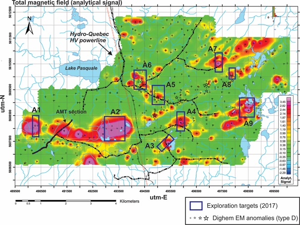
Based on these observations, INRS defined nine exploration targets (see Figure 1).
Click Image To View Full Size
Figure 1. Exploration targets A1 to A9 as defined by Mark Richer-LaFleche (INRS, 2017). Base map is the analytical signal calculated from the total magnetic field ("TMI"); data from Fugro's 2011 airborne DIGHEM survey of Decouverte.
As reported on November 20, 2017, Danae Voormeij, PGeo, has been retained to interpret all relevant data on Decouverte towards a geological model and first drill program for the Property. Ms. Voormeij states: "the recent interpretations by INRS on the ground geophysical surveys they completed are a critical component in defining and ranking drill targets for the upcoming program. The geophysical targets are being combined with field data from geological mapping and rock, till and soil sampling, previously completed at Decouverte." Additional updates on this program will be released as they become available.
About Decouverte
The Property is in the Frotet-Evans greenstone belt, along the same shear zone as the former Troilus copper-gold mine, located approximately 60 kilometres to the northeast, which produced over two million ounces of gold and 50,000 tonnes of copper from 1997 to 2010 and has an estimated remaining resource (2016) of another two million ounces of gold. Durango is targeting orogenic shear-zone hosted gold mineralization and gold-rich VMS-style deposits at Decouverte.
The Property covers a section of the main anastomosing Frotet-Troilus shear-zone where it bends from trending east-west to northeast. The dominant structural feature is a large synclinal fold nose composed of Archean metasedimentary and metavolcanic rocks that has been deformed by northwest and northeast-trending faults and intruded by syn-orogenic granodiorite bodies.
The technical information contained in this News Release was prepared by Danae Voormeij, MSc, PGeo. Ms. Voormeij is a qualified person under CIM's National Instrument 43-101 Standards of Disclosure for Mineral Projects.
About Durango
Durango is a natural resources company engaged in the acquisition and exploration of mineral properties. The Company has a 100% interest in the Mayner's Fortune limestone property and the Golden Triangle properties in northwest British Columbia, the Decouverte and Trove & Windfall gold properties in Quebec, lithium properties near the Whabouchi Mine, the Buckshot graphite property near the Miller Mine in Quebec, the Dianna Lake silver project in northern Saskatchewan and the Whitney Northwest gold property near Timmins, Ontario.
For further information on Durango, please refer to its SEDAR profile at www.sedar.com or contact:
Marcy Kiesman, Chief Executive Officer
Telephone: 604.339.2243
Email: durangoresourcesinc@gmail.com
Website: www.durangoresourcesinc.com
Forward-Looking Statements
This document may contain or refer to forward-looking information based on current expectations, including commencement and completion of future exploration and the impact on the Company of these events. Forward-looking information is subject to significant risks and uncertainties, including market conditions, raising additional capital for exploration expenditures, as actual results may differ materially from forecasted results. Forward-looking information is provided as of the date hereof and we assume no responsibility to update or revise them to reflect new events or circumstances. For a detailed list of risks and uncertainties relating to Durango, please refer to its prospectus filed on its SEDAR profile at www.sedar.com.
Neither TSX Venture Exchange nor its Regulation Services Provider (as that term is defined in the policies of the TSX Venture Exchange) accepts responsibility for the adequacy or accuracy of this release.
Copyright (c) 2017 TheNewswire - All rights reserved.
